Detailed Site Proposals
This section develops the three shortlisted sites into full proposals — site description, design approach, phasing, risks, and the case for each. Cost breakdowns, funding strategies, and revenue projections sit in § F Finance — consolidated there so the public-facing narrative in this section reads as a comparison of approach rather than of price.
6.1 Askew Road
6.1.1 Site description & context
A central 842 m² site off Askew Road in Gateshead, already carrying street-art character that aligns with skateboarding culture. The site is walkable from the town centre and well-placed for public-transport access. The skatepark plot itself is council-owned. The seven adjacent railway arches are owned by Network Rail, and no structures may be built off them — which is why the covering is designed as a free-standing canopy on its own columns rather than spanning from the arches.
6.1.2 Railway arches — supporting infrastructure
Seven gated railway arches sit alongside the site, currently locked and featuring existing graffiti artwork. They are owned by Network Rail and have electricity supply but no plumbing. The skatepark structure is fully independent of them and does not rely on Network Rail. Phase 1 fits out two arches — Arch 2 (toilets) and Arch 6 (storage) — which depends on securing an early use-agreement with Network Rail to occupy them; the remaining arches are an optional later-phase upside if a further arrangement is agreed. Each arch is scoped below.
| Arch | Proposed use | Notes |
|---|---|---|
| 1 | Cafe / social hub | Plumbing required; can share supply with Arch 2 |
| 2 | Toilet / amenities block | Plumbing required; Phase 1 amenity (needs early Network Rail use-agreement) |
| 3 | Skate shop / equipment hire | Minimal additional fit-out |
| 4 | Coaching / workshop space | Indoor session and wet-weather overflow |
| 5 | Community / events space | Competitions, exhibitions, film, creative use |
| 6 | Storage / maintenance | Phase 1 storage (needs early Network Rail use-agreement) |
| 7 | Gallery / heritage space | 5 Bridges archive and rotating exhibitions |
Note. The skatepark itself — plot, canopy and skating surface — is delivered on council-owned land with no Network Rail involvement. Phase 1 additionally fits out Arch 2 (toilets) and Arch 6 (storage), which requires an early use-agreement with Network Rail to occupy those two arches — the scheme's one Network Rail dependency, and a use-agreement rather than a structural one. The remaining arches (café, shop, workshop, events, gallery) are an optional later-phase upside, contingent on a further Network Rail arrangement.
6.1.3 Design concept
Shred The North engaged Betongpark Ltd — the UK office of the Norwegian skatepark designer-builder — to develop concept design for the project. Across that engagement, Shred The North and Betongpark agreed Askew Road as the front-running site; Betongpark's concept design report (dated ) documents the supporting site comparison and develops the design for Askew Road specifically. The brief asked for a dense plaza-focused layout taking advantage of the compact footprint. The returned concept treats the 842 m² open plot as the skating space, with a purpose-built free-standing steel canopy providing weather cover, and the seven Network Rail-owned railway arches available along one edge for optional future commercial and services uses — café, skate shop, toilets, storage (see § 6.1.2). A “FIVE BRIDGES” memorial plinth is sited at the entrance, giving the original park a permanent place at the heart of the new one.
Betongpark frame the brief as “drawing inspiration from what made Five Bridges so special”, with the concept aiming to produce “an open and versatile space that reflects the character and legacy of the original park” (Betongpark, 2026-05-16, p. 2).
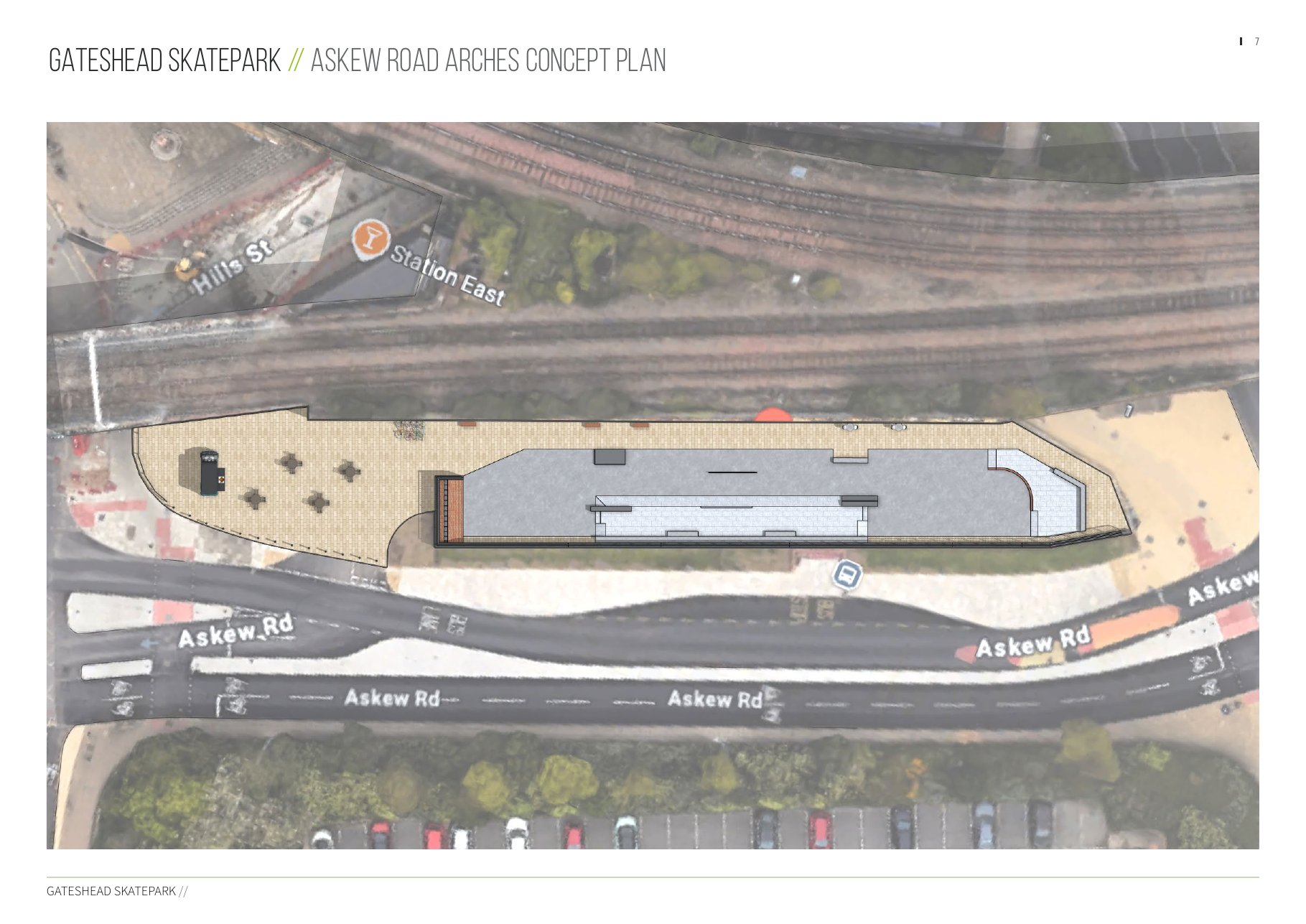
Plan view — the 842 m² plot alongside the railway arches, with the covered skating area and entrance plinth. Source: Betongpark, 2026-05-16, p. 7.
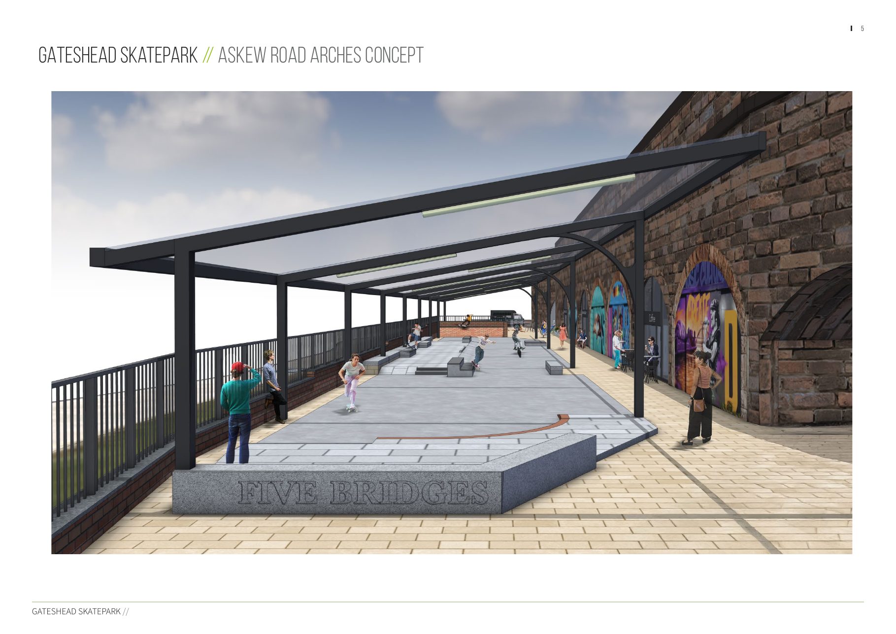
Concept render — entrance view with the “FIVE BRIDGES” memorial plinth in the foreground. Source: Betongpark, 2026-05-16, p. 5.
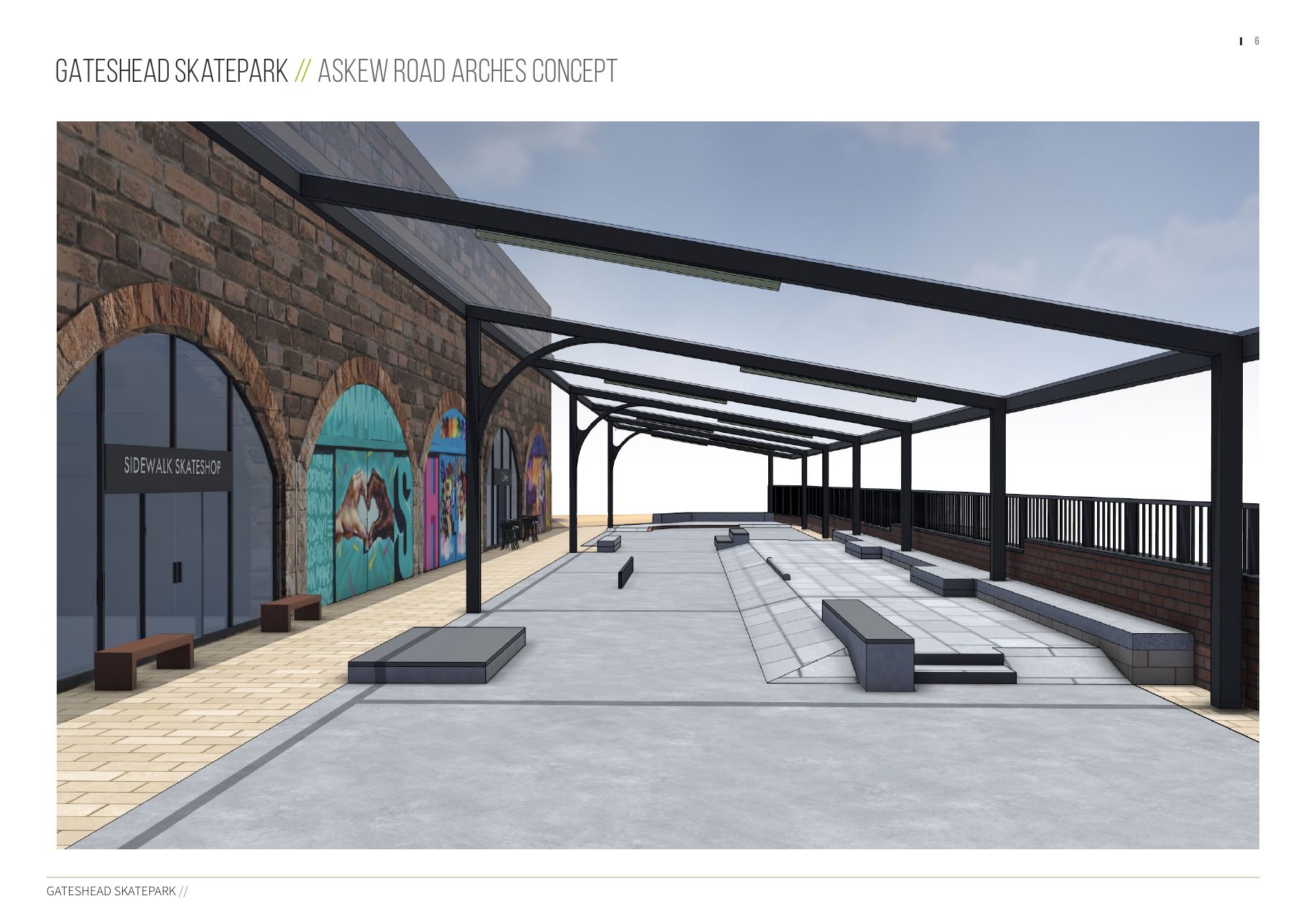
Concept render — view along the arches showing one of the proposed commercial uses (skate shop) at the frontage. Source: Betongpark, 2026-05-16, p. 6.
A further set of concept views was issued by Betongpark on 2026-05-26, giving additional eye-level and aerial perspectives of the covered scheme on the open plot and its relationship to the railway arches and Askew Road.
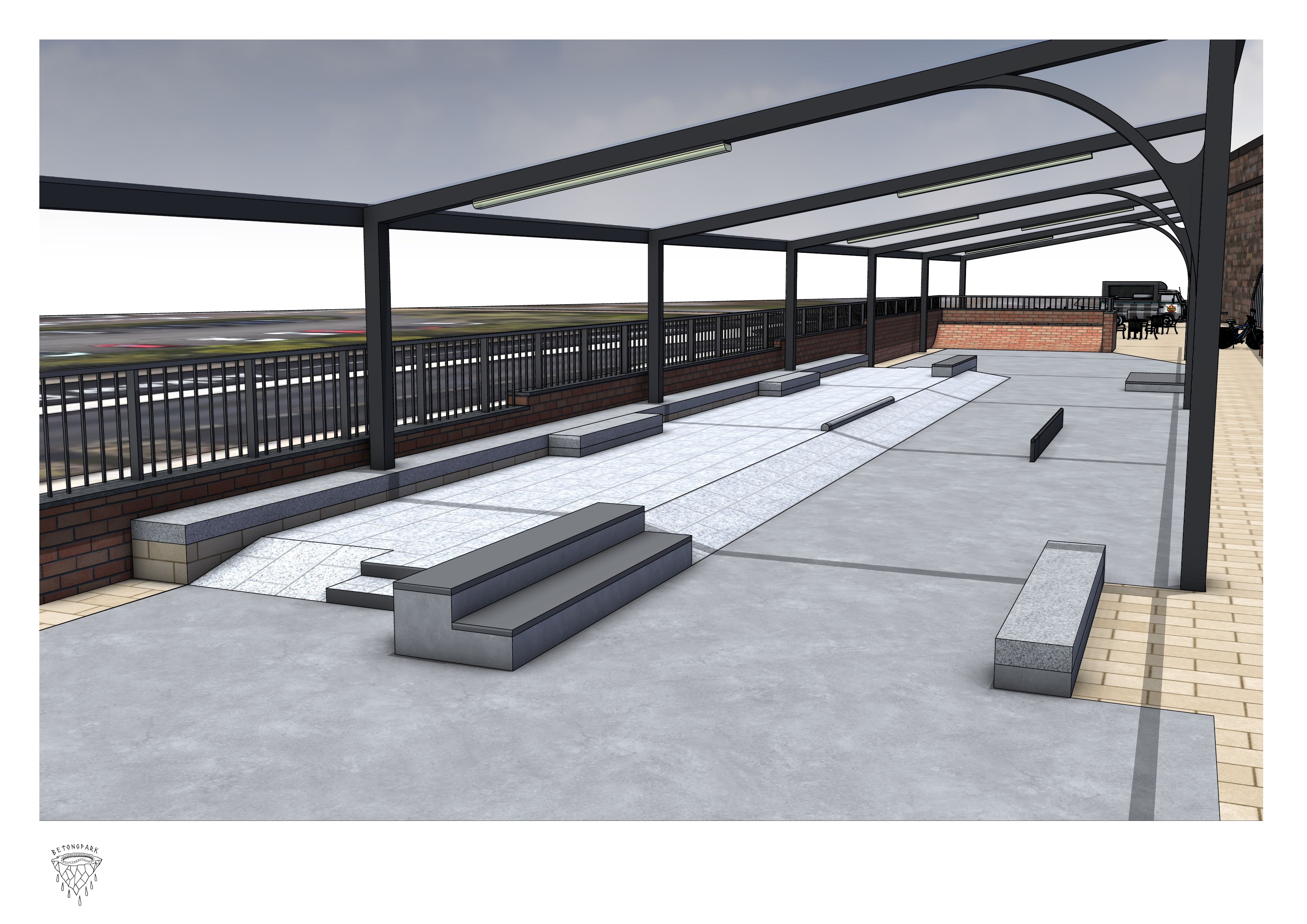
Plaza overview — the covered street section beneath the steel canopy, with ledges, manual pads and perimeter seating. Source: Betongpark, 2026-05-26, p. 1.
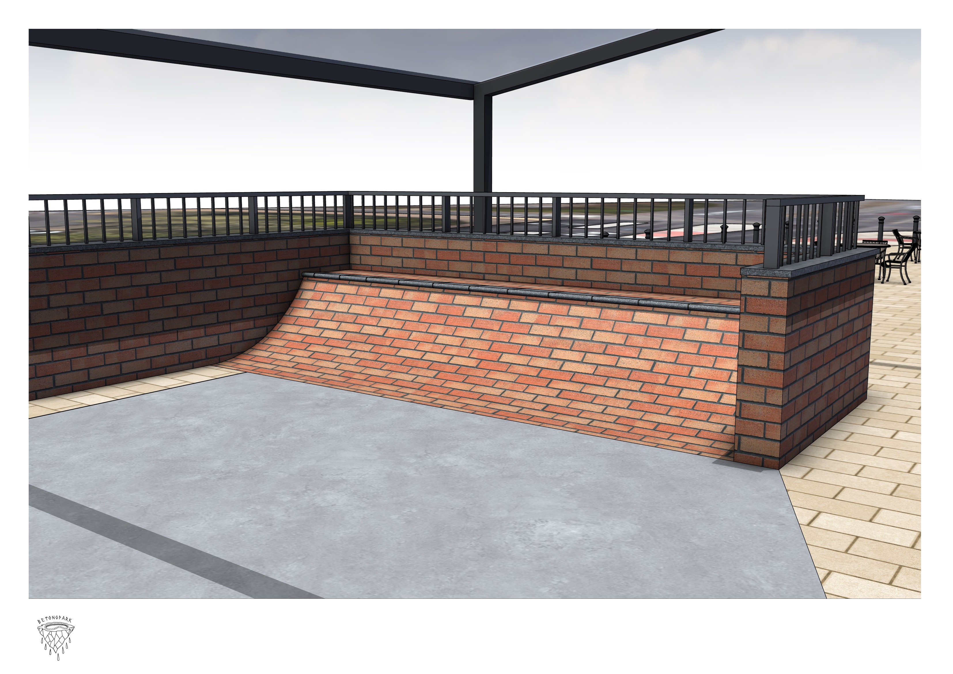
Brick bank detail — a brick-faced bank with coping along the railway edge. Source: Betongpark, 2026-05-26, p. 2.
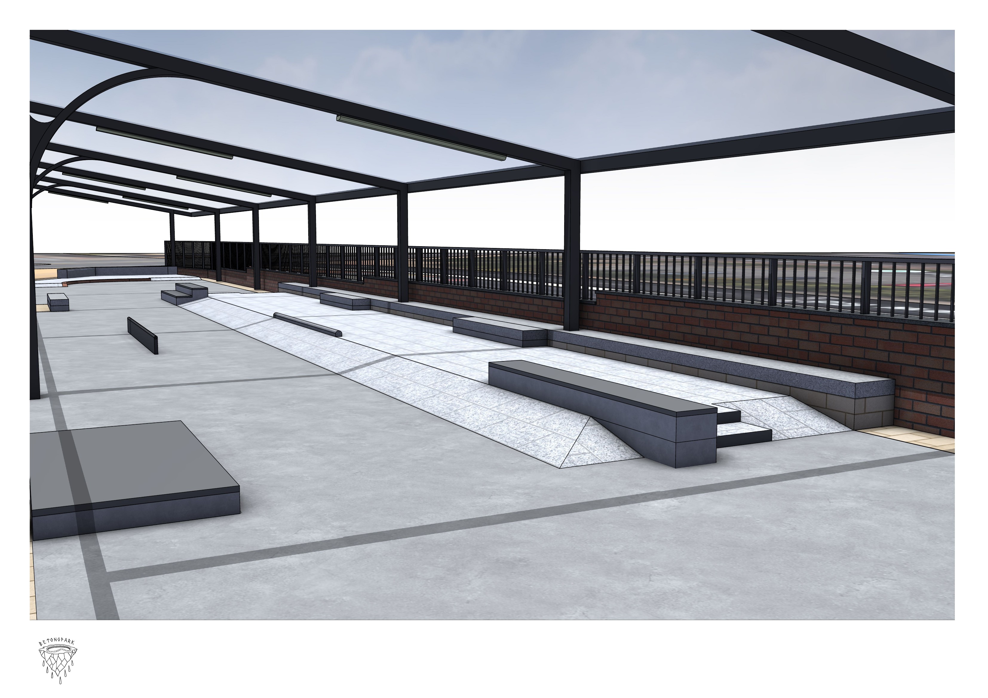
Street features — the run of ledges, manual pads and rails under the canopy. Source: Betongpark, 2026-05-26, p. 3.
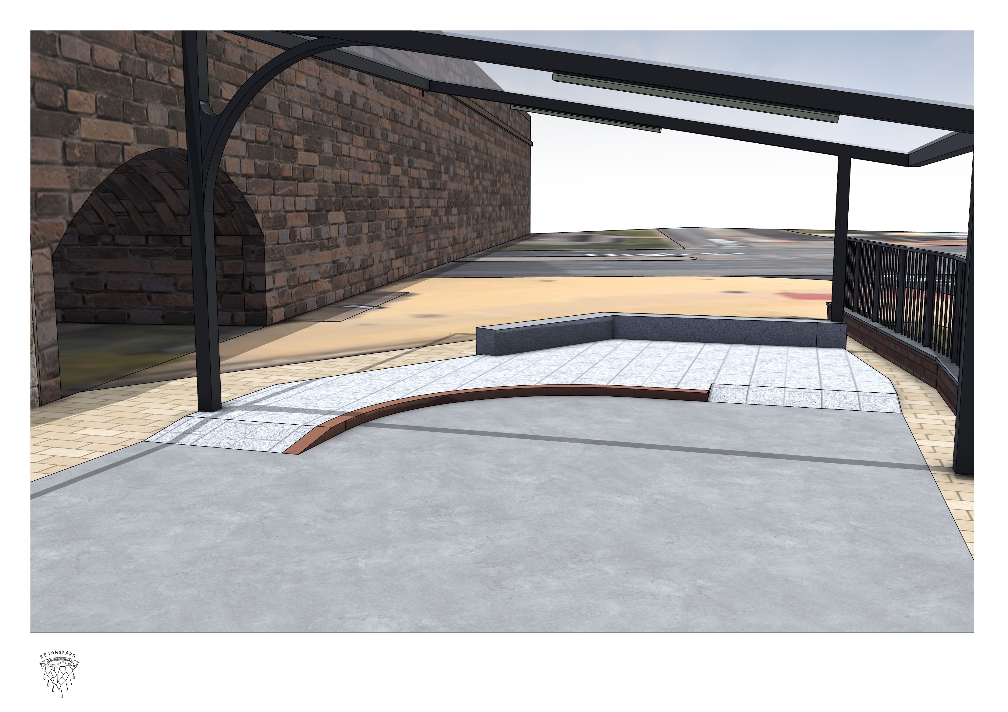
Arch and bank — the scheme alongside the existing masonry railway arch, with a curved bank on the open plot. Source: Betongpark, 2026-05-26, p. 4.
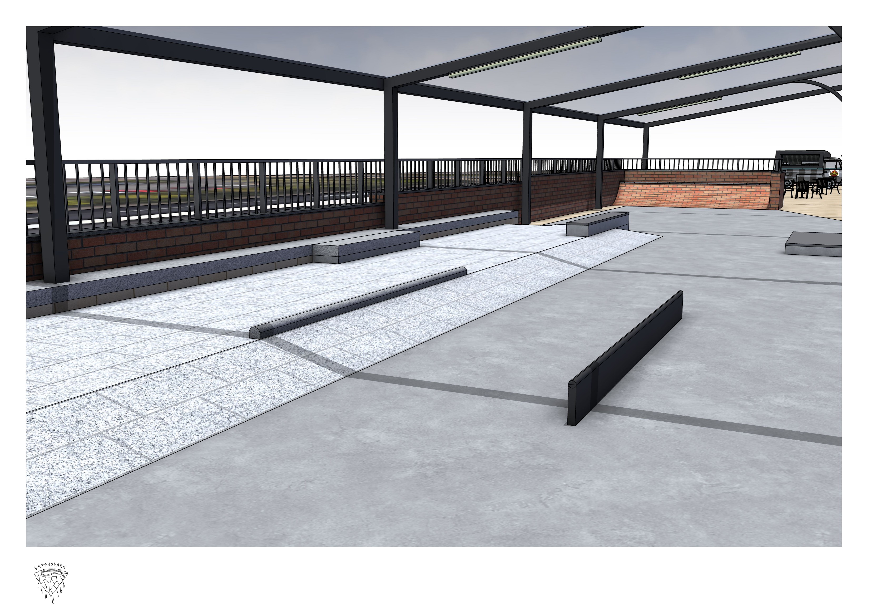
Flatground and rails — the open flatground with flat-rail and granite-topped ledges. Source: Betongpark, 2026-05-26, p. 5.
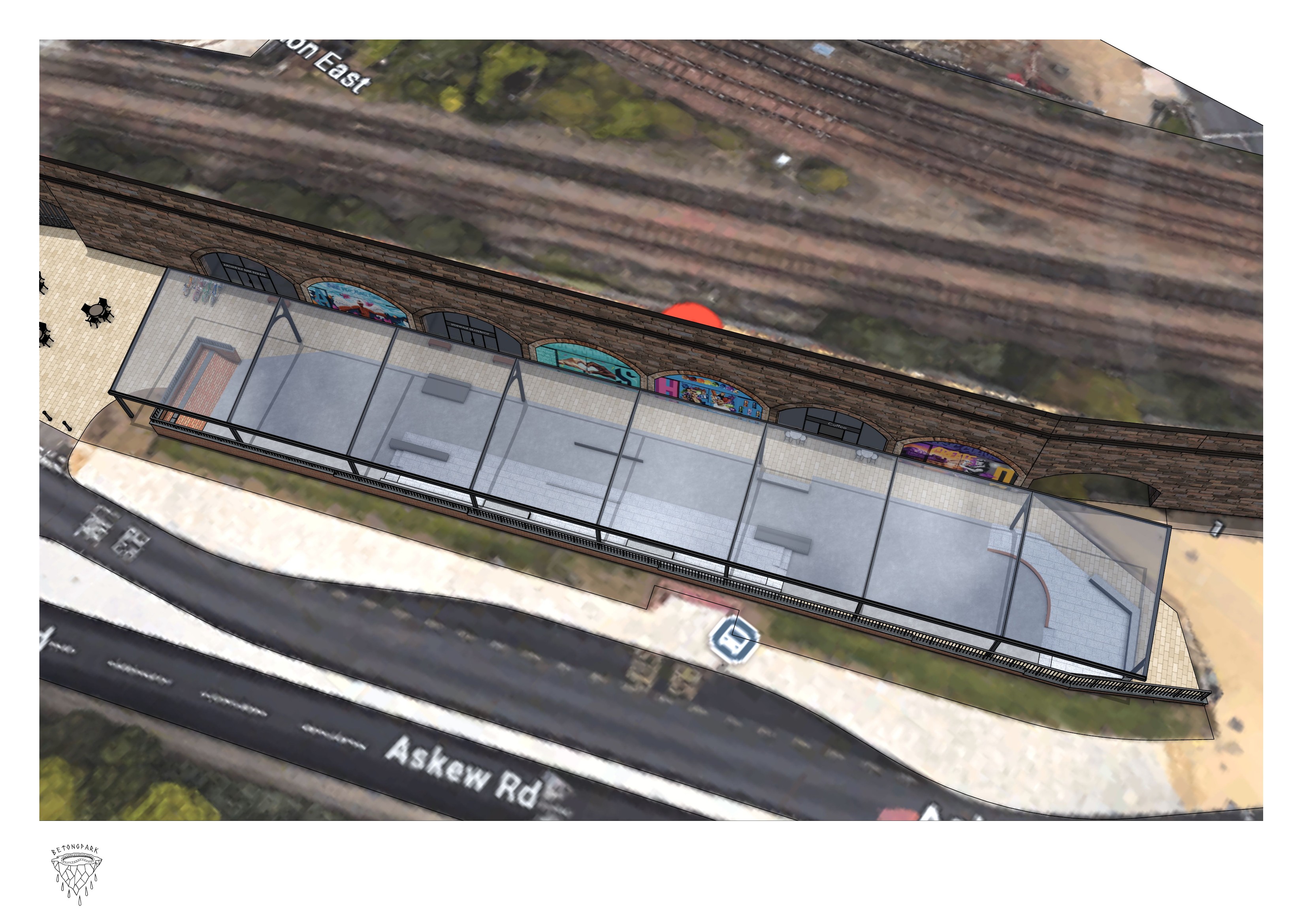
Aerial massing — the covered enclosure in context between Askew Road and the railway line. Source: Betongpark, 2026-05-26, p. 6.
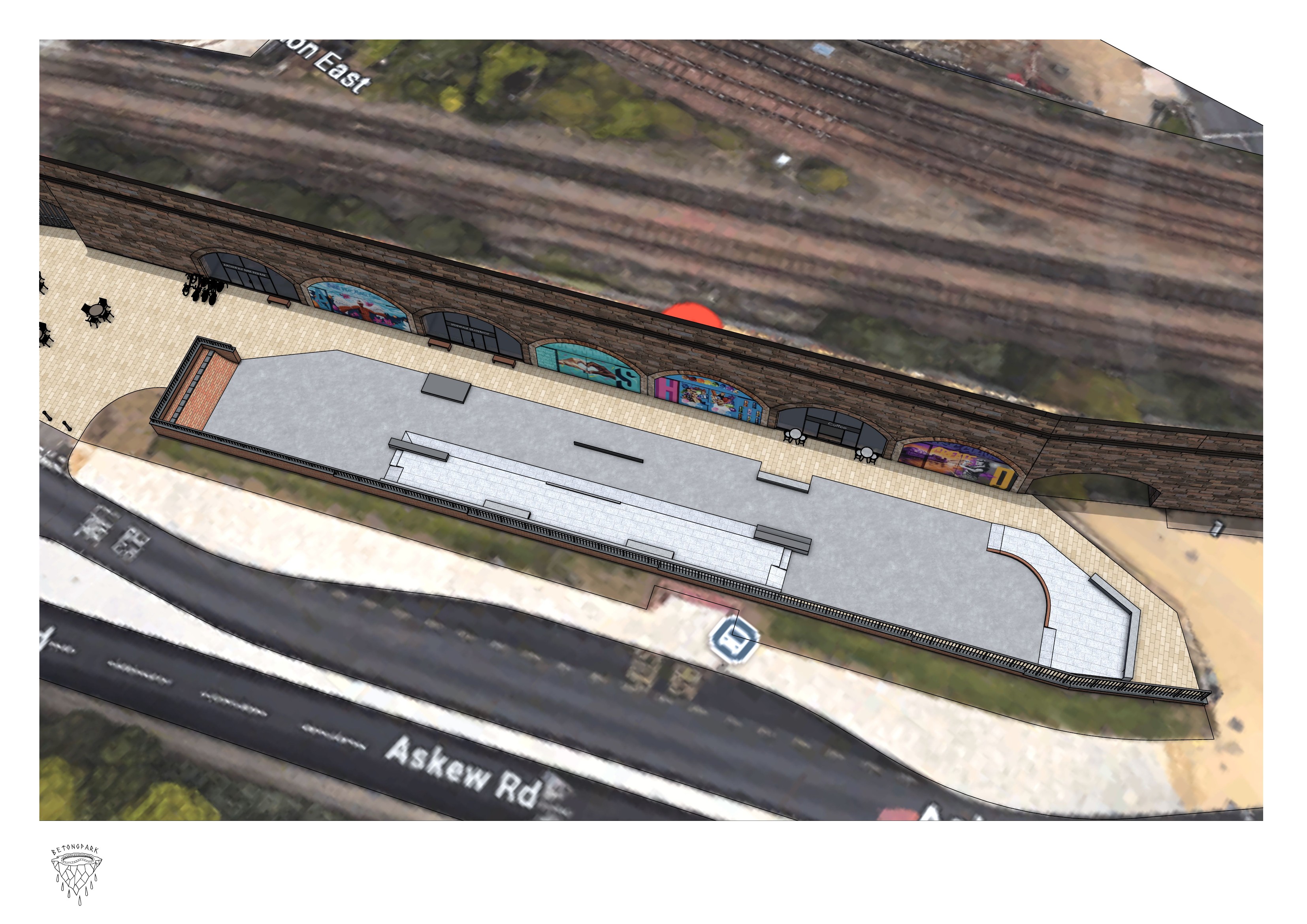
Aerial layout — the internal skatepark layout within the covered footprint. Source: Betongpark, 2026-05-26, p. 7.
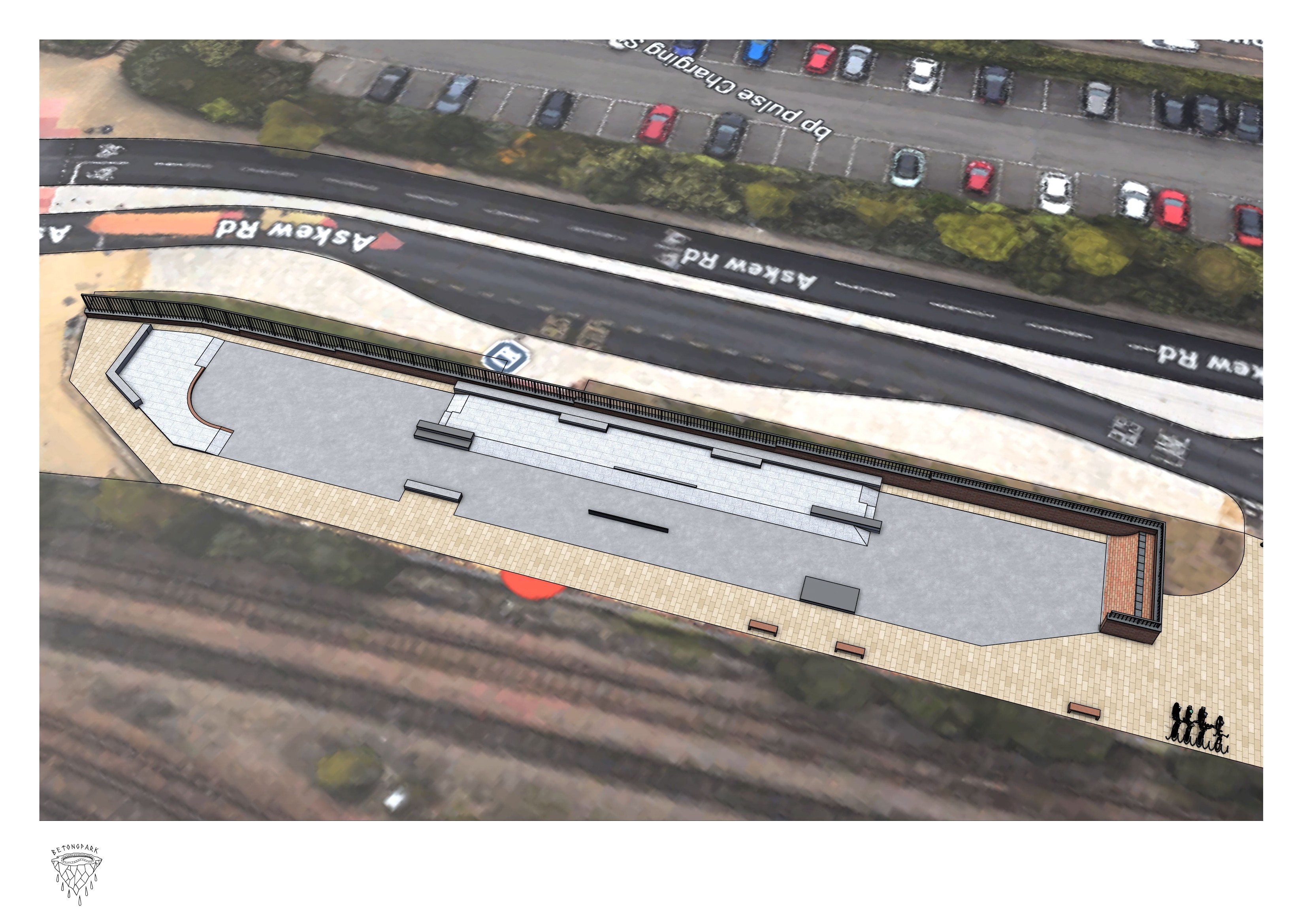
Aerial from Askew Road — the full tapered plot seen from the road and car-park side. Source: Betongpark, 2026-05-26, p. 8.
Betongpark's report records the five sites considered during the engagement — NFL Pitch, Gateshead Quays Multi-Storey Car Park, Interchange, Loverose Lane, and Askew Road Arches — and the agreed conclusion that “Askew Road Arches has emerged as the strongest and most promising option for a new skateable space” (Betongpark, 2026-05-16, p. 3). This is the supplier-side documentation of the front-runner position adopted in § 7 Recommendations.
Note on equipment. The renders show new-build street features (banks, ledges, manual pads) and are illustrative of style and density rather than the final Phase 1 specification. Phase 1 build will integrate reusable obstacles relocated from the original 5 Bridges Plaza in the same plaza/street language. Final equipment layout is a co-design step with the skating community after council approval.
6.1.4 Phasing plan
- Phase 1 (Year 1). Ground preparation and covering (500–670 m²); relocated 5 Bridges equipment; Arch 2 (toilets) and Arch 6 (storage) fitted out, subject to an early Network Rail use-agreement for those two arches.
- Phase 2 (Years 1–2). Arch 1 (cafe) and Arch 3 (skate shop); shared plumbing installation; additional equipment.
- Phase 3 (Years 2–5). Arches 4 (coaching), 5 (events), and 7 (heritage gallery); covering extension; public-realm works.
6.1.5 Heritage & cultural value
The existing graffiti artwork, rather than being treated as a problem to be removed, is a cultural asset to be documented and where possible preserved. Arch 7 as a dedicated 5 Bridges heritage gallery would give the region a permanent home for the history, photos, and memorabilia of the original park, and aligns with the funding criteria of heritage- focused grant bodies (see § F.4).
6.1.6 Strengths & considerations
Strengths: the most central of the three sites; higher achievable coverage percentage than Stadium; arches transform the offer from a skatepark into a hub with supporting services and revenue potential; Phase 1 feels complete at a smaller footprint; authentic character already in place.
Considerations: smaller footprint limits scale and expansion; residential proximity affects operating hours and noise management. The skatepark structure is free-standing on the council-owned plot and does not rely on Network Rail; Phase 1 fits out two Network Rail arches for toilets and storage, which needs an early Network Rail use-agreement, and the remaining arches are an optional later-phase upside.
6.1.7 Delivery timeline & risk register
Site visit (May 2026) and supplier concept design (Betongpark, 16 May 2026) are in; outline timelines are embedded in § 6.1.4 and § 5. The formal Phase 1 / 2 / 3 Gantt with critical-path dependencies and a structured risk register (covering planning, residential noise management, supplier delivery, the early Network Rail use-agreement and plumbing fit-out for the Phase 1 amenity arches, and — as optional later-phase upside — any further Network Rail arrangement for the commercial arches) would be produced in a Phase 2, if the council progresses the project.
6.1.8 Cost & funding
Askew Road Phase 1 / 2 / 3 cost envelope, per-arch fit-out, arches revenue projections (café / shop / events lease), and funding stack are in § F.2.1 (cost) and § F.5.1 (revenue). If the council progresses to a Phase 2, contractor quotes would firm up the bracketed working estimates currently in those sections.
6.2 Gateshead Stadium
6.2.1 Site description & context
Gateshead Stadium is a council-owned sports complex with a 4,883 m² site available for a skatepark within its grounds — the stadium's defunct American football pitch. The location provides vehicular and pedestrian access, existing utilities, and immediate adjacency to other active-sports infrastructure. The site is council-owned; the exact siting of the skatepark within the complex is to be finalised with the council.
6.2.2 Design concept
Concept design for this site has not been commissioned at this stage of the study; it would be a next-step deliverable if the council selects Stadium as the preferred option. An aerial view of the proposed plot — the stadium's defunct American football pitch — sits below as the visual reference for this section, as no photographs were collected on the May 2026 site visit. Cf. § 6.1.3 where worked-up concept design from Betongpark has been developed for Askew Road following STN's supplier engagement on the front-running site.
6.2.3 Phasing plan
A phased build suits the site and the budget envelope:
- Phase 1 (Year 1). Ground preparation across the skateable area; partial covering over approximately 2,000 m²; relocated 5 Bridges equipment arranged within the covered zone; basic amenities (fencing, signage, bins, lighting).
- Phase 2 (Years 2–3). Additional equipment; extended covering; seating and improved lighting; integration with stadium operations where applicable.
- Phase 3 (Years 4–5). Premium features, events infrastructure, cafe or community space as demand and funding support.
6.2.4 Stadium integration
Co-location with an active sports complex is a genuine advantage, not a compromise. Shared amenities (toilets, parking, potentially catering) reduce what the skatepark itself has to provide. Cross-programming with stadium events creates year-round activation, and the combined offer strengthens the Stadium's own community value. The detailed partnership model (operations, access, scheduling) is a Phase 2 deliverable, to be worked up with council estates and stadium operations if Stadium is selected.
6.2.5 Strengths & considerations
Strengths: largest footprint of any option; council-owned; low deliverability risk; scope for long-term growth; compatible adjacent use.
Considerations: a Phase 1 build can feel sparse on a site this large until further phases complete; covering is a new structure (design and build cost); least central of the three shortlisted sites.
6.2.6 Delivery timeline & risk register
A full Phase 1 / 2 / 3 Gantt with critical-path dependencies (council approval → design → planning → procurement → construction → opening), and a structured risk register covering planning, structural, procurement, weather, and operational risks with mitigations. Outline timelines are embedded in § 6.2.3 (phasing) and § 5; the formal Gantt and risk register would be produced in a Phase 2, if the council progresses the project.
6.2.7 Cost & funding
Stadium Phase 1 / 2 cost envelope and co-location revenue projections (café sales, cross-facility usage, events, vending, sponsorship; mid-point £60–80k/year) are in § F.2.2 (cost) and § F.5.2 (revenue). If the council progresses to a Phase 2, contractor quotes would firm up the bracketed working estimates currently in those sections.
6.3 Car Park Conversion (site TBC)
6.3.1 The approach
Adaptive reuse of an under-used multi-storey car park. The building is already built: slabs, columns, roof cover, lighting conduit, drainage, and ventilation are in place. The design question is how to adapt what exists rather than how to build something new. A typical enclosed car park level offers ~3,000 m² of footprint with the roof already overhead.
If the council chooses to progress this approach, the next step is identifying a specific candidate building. Rather than commit to a particular car park in this study, this section makes the case for the approach and sets out what a suitable candidate would need.
6.3.2 Identifying a site
Candidate criteria the council would apply when selecting a car park:
- At least one enclosed level of ~3,000 m² with a realistic path to control (council-owned, or securable on acceptable terms).
- Floor-to-ceiling of 2.4 m or more on the proposed level (lower levels can still work but reduce feature range).
- Column grid workable for a plaza/street layout (typical 7–8 m spacing is acceptable).
- Compatible surrounding use and access (not a live, fully-utilised commuter car park).
- Town centre, Quays, or regeneration-area location to maximise catchment and policy alignment.
Several candidates exist across Gateshead; site identification is a council-led task outside the scope of this study.
6.3.3 The 5 Bridges connection
5 Bridges worked because it activated existing transport infrastructure — the Tyne flyover — for skateboarding. A multi-storey car park conversion follows the same logic: repurposed urban infrastructure, raw concrete character, built-in shelter. For a replacement, that parallel is more than aesthetic. The thing that made 5 Bridges distinctive was a roof it didn't pay for. A car park conversion gives the region that back.
6.3.4 Design concept
Concept design for this approach has not been commissioned at this stage of the study because it is gated on site selection — a council-led step that is yet to be taken. Generically, the working assumption is a plaza/street layout with low-profile transition features on enclosed levels and (if the chosen building has a usable top deck) an open-air transition zone. Cf. § 6.1.3 where worked-up concept design from Betongpark has been developed for Askew Road following STN's supplier engagement on the front-running site.
For visual reference, see the Cabot Circus Skate Spot — a sanctioned skateable installation on Level 7 of the Cabot Circus car park, Bristol, designed by Canvas Skateparks and Public Spaces for Hammerson plc in October 2022 (host venue for the Red Bull Curb Kings competition, described by the venue as the first of its kind in the UK). The Cabot Circus activation was temporary; it is referenced here as a design-feel reference for skateable obstacles integrated into a working multi-storey car-park interior, not as a structural or operating precedent. A site-specific concept design for a Gateshead car park would be a next-step deliverable once a candidate building is identified.
6.3.5 The covering question
Every level below the roof deck is already 100% covered. There is no covering structure to design, fund, or build. The community priority that is hardest to meet on a new-build site — weather protection — is effectively resolved from day one. The trade-off is the ceiling height constraint: standard halfpipes and bowls need 3–4 m+ clearance, which typical car-park levels (2.4–3.0 m) cannot provide. The 5 Bridges terrain was predominantly plaza and street, which fits comfortably within those heights; transition-heavy programmes would need a top deck.
6.3.6 Phasing plan
- Phase 1 (Year 1). Single-level conversion: surface preparation, equipment, lighting upgrade, safety works.
- Phase 2 (Years 1–2). Additional equipment and amenities; second-level conversion or top-deck activation; cafe or social space within the structure.
- Phase 3 (Years 2–5). Top-deck transition area, events infrastructure, art and mural programme, multi-level flow design.
6.3.7 Strengths & considerations
Strengths: full covering exists from day one; significant scale across multiple levels; lowest build envelope because the structure exists — spend shifts to surface and equipment where the community most values it; strong alignment with town-centre activation and regeneration agendas; authentic adaptive-reuse character.
Considerations: site identification is a prerequisite step; ceiling height limits transition and bowl features on enclosed levels; column grid constrains layout and sight lines; noise reverberation and ventilation need design attention; acoustics management may be more significant than in a new-build covered venue.
6.3.8 Delivery timeline & risk register
The guidelines in this section apply to any qualifying sheltered car park; the council selects the specific building. Once a building is chosen, a structural condition survey, change-of-use planning timeline, and full Phase 1 / 2 / 3 Gantt populate here, alongside a risk register covering structural life expectancy, change-of-use planning, ceiling and column constraints, ventilation and acoustics, leasehold, and — if the chosen car park falls within the Quays area — any Quays masterplan implications.
6.3.9 Cost & funding
Car Park conversion Phase 1 / 2 / 3 cost envelope (surface preparation, lighting, equipment, safety works, multi-level expansion) and the funding-alignment narrative for Quays regeneration and creative-reuse routes are in § F.2.3. Ranges are wider than the other two options because they are site-independent — the structural survey on the chosen building is the gating step before figures firm up.
6.4 Summary
Each of the three sites is genuinely viable and each is good at something the others aren't. The Recommendations section reconciles the three against the weight of evidence from survey, interviews, and site assessments — supplemented by the cost picture in § F Finance — and identifies a preferred option with supporting rationale and next steps.